

A Glimmer of Hope for Seagrass in the Wakatobi National Park?
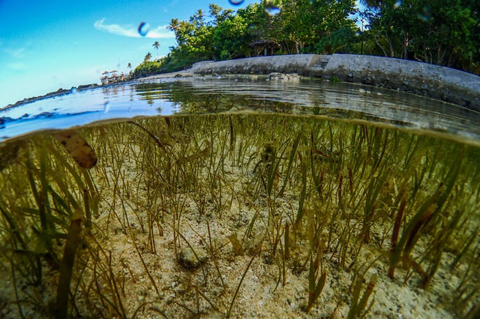
Back in December 2015 I spent a couple of weeks in the Wakatobi, Indonesia, initiating phase II of the Wakatobi Seagrass Program. This seeks to build on work carried out though a previous project “Recognising the role of seagrass meadows in food security: re-prioritising the marine conservation agenda” (2011-2014), which was conducted in the same location. That project evidenced the direct economic value and food security potential of seagrass meadows and prompted local government and community stakeholders to place seagrass on their conservation agendas for the first time. The Wakatobi project demonstrated how seagrass associated species provide an essential source of protein and income to the vast majority of people in the region. We provided evidence of the links between seagrass and food security and highlighted that these currently expansive ecosystems remain largely ignored within formal legal or environmental management frameworks, even within an MPA at the heart of the Coral Triangle. Seagrass meadows provide an essential source of protein and income to the vast majority of people in the region. The outputs from the first project are being used to drive forward discussions between local stakeholders to bring about change. And although their value is somewhat recognised in the Wakatobi, these expansive ecosystems are threatened by a myriad of anthropogenic activities. The host of threats at play within the Wakatobi range from mangrove destruction to overfishing and aren’t going to disappear overnight. Phase II of the Wakatobi Seagrass Program seeks to work on these threats through local, community level action, and devising strategies to work with formed the basis of my trip. Seagrass meadows across the Wakatobi are threatened by a host of factors. Overfishing has left many meadows lifeless. As communications developed with our local partner, FORKANI, it seemed clear that one of the issues they felt was dominant, was the issue of run-off. Terrestrial run-off causes huge problems for seagrass through both sedimentation and eutrophication, and as the destruction of mangroves (15% of mangrove forest has been destroyed by local community members seeking firewood and construction materials) and forest areas continues, the ability for land to absorb and store water lessens. Given this, FORKANI proposed an exciting idea to rehabilitate both mangrove and forest areas around rivers in 3 key villages, not only to reduce impact on seagrass but to improve the continually worsening problem of water storage on the island of Kaledupa. However, with so much forest now converted to palm plantations, choosing areas to rehabilitate wasn’t going to be an easy task, and choosing areas that were key was even harder. FORKANI were amazingly resourceful when it came to the practicalities of choosing locations, mapping each river in a way that made it easy to pin point areas that needed the most work. Sometimes working the old fashioned was has its perks, and the relative ease in which they categorised each river was efficient and effective. FORKANI have now chosen areas to rehabilitate and are currently working on preparing the areas and seedlings, while also beginning to monitor seagrass in front of each village to track their own progress. Conducting river mapping was efficient and effective and allowed FORKANI to choose key areas for rehabilitation Even though discussions were productive, overfishing is still the “elephant in the room” that nobody wants to talk about. Although dynamite and cyanide fishing are now almost absent across the national park, at least that’s what we’re told, the unsustainable removal of juvenile fish is still a widespread issue. Fish fences, or “sero” as they are locally called, are one of the biggest issues facing the Wakatobi National Park and tentative UNESCO World Heritage Site. These fish fences, scar’s upon the face of the park’s beauty, fish 24/7 and, as we’ve discovered, are not only restricted to seagrass meadows. Fish fences have left both reefs and seagrasses looking like barren wastelands. Fishing 24/7. The Sero are non selective and never stop fishing Tackling the overfishing problem will take time, but by tapping into the past, we can begin to improve the future of the Wakatobi’s coastal fisheries. For centuries, isolated communities across the globe have respected a delicate balance with the ocean — taking fish only from certain areas, of certain sizes and with specific methods to maintain a healthy ecosystem and supply of fish for present and future. Now, with two key fishing villages keen to work on adopting community managed no-take areas there is some serious hope for the future. This solution, which builds on and adapts successful fisheries management techniques, provides a win-win for coupled socio-ecological systems, protecting fishers wellbeing as well as the health of marine ecosystems. Systems like this, that are well-managed, result in more fish — and not just by a few. By adopting this formula, and continually managing their fishery, communities can expect to see a potential increase of up to 56 percent in fish abundance and a potential increase in yield of up to 40%. In 2006, then Indonesian President Susilo Bambang Yudhoyono made a hugely ambitious promise to conserve a “global epicentre of marine life abundance and diversity”, stating that Indonesia would preserve 10 million hectares of ocean lying in the Coral Triangle. In 2009, he doubled this commitment to 20 million hectares by 2020. The the 1.39 million hectare Wakatobi National Park contributes to the 16.6 million hectares already protected – but given the status of seagrasses and the vast overfishing problem, serious questions about the meaning ‘protected’ arise. Is the Wakatobi destined to become a site of World Heritage value or just a wasteland? The Wakatobi’s communities are centre to answering this question. Although their sense of ownership always has been present, with these proposed mitigation measures being taken a little more seriously by communities, its clear that with a little motivation the people of Kaledupa can be tremendously proactive. This gives us a glimmer of hope for seagrass in this dynamic region of the world. The future of the Wakatobi is dependent on its communities, yet the
Restoring our Damaged Seagrass Meadows
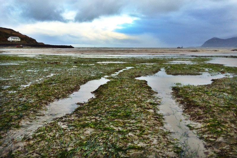
When you think about areas requiring bold initiatives to protect the environment, the small Welsh costal village of Porthdinllaen might not be the first place that comes to mind, and with only two dozen buildings and a miniscule population you might find it surprising that the environment there is under threat. Porthdinllaen is a part of a marine conservation area called Pen Llŷn a’r Sarnau Special Area of Conservation (SAC) which extends from Nefyn, on the north coast of the Llŷn, to Clarach, about a mile north of Aberystwyth. The presence of seagrass within the SAC is one of the reasons the area is so special. Due to its location, sheltered from all but north-easterly winds, Porthdinllaen is the perfect place for seagrass to grow and as such the seagrass meadow there is thought to be the largest and densest in Wales covering an area the size of 46 football pitches. However, its natural sheltered location also makes it an ideal natural harbour, and it is here where the problems lie. The sheltered harbour, the only such haven on the Llŷn Peninsula, has been used for many centuries as a place to run to for shelter in a storm offering safe anchorage. It is now a lively, but small fishing port with around 90 moorings, each of which is having a negative effect on the seagrass meadow. Damage of boat moorings within the seagrass meadow at Porthidinllaen It’s estimated that around 10% of the seagrass at Porthdinllaen has been lost due to moorings alone, but moorings aren’t the only problem. Anchoring within the seagrass meadow is also a common sight. By far the biggest concern within the extensive intertidal seagrass meadows of the site are tractors and 4×4 vehicles, which routinely cross the seagrass to retrieve the fishermen’s catch. These issues fragment the seagrass causing it to become patchy and no longer a continuous area of habitat for fish. Fragmented meadows are more vulnerable to the effects of erosion. Tractor damage to the Porthdinllaen seagrass meadow Not all doom and gloom! Its not all doom and gloom though, Project Seagrass has now begun the first ever seagrass restoration trial in Wales with the hope of developing a novel method to restore our damaged seagrass meadows and consequently help support our declining fisheries. Interest in seagrass restoration in the UK is increasing as the value of seagrass ecosystems is recognized by scientists, managers and regulators. However, despite this interest action remains limited. The UK Biodiversity Action Plan for seagrass beds specifically details the restoration of 1000 hectares of seagrass during 1997-2010. Transplantation trials in the 1980’s, the early 1990’s and in the last two years were carried out around the south coast of England, but with little success in the long-term. No seagrass in the UK has been restored to date. Seagrass seeds ready for sorting During our 2015 summer SeagrassWatch survey we collected a number of Zostera marina shoots laden with seeds. Having let the seeds harden and mature within their seed pods in the aquaria at Swansea University we then sorted the seeds and placed them into hessian bags, ready for planting. During our autumn 2015 SeagrassWatch survey we buried these bags in areas of bare sediment and will check the progress during our 2016 winter, spring, summer and autumn surveys. Despite some poor survey conditions, we planted over 1,500 seeds. If this trial is successful we hope to continue and expand the restoration trial across Wales introducing seeds from other areas to create a genetic mix that allows for hardier and more resilient seagrass meadows in the face of environmental stresses, such as climate change. Planting the hessian bags at Porthinllaen
Starting the Seagrass and Dugong fightback
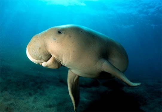
The Dugong (Dugong dugon) is IUCN Red listed as Vulnerable, in many of the 46 range states that contain Dugong its status is a lot worse. Historic hunting, loss of its seagrass habitat and the impacts of by-catch have been the primary causes of its decline. Back in 2007 the Secretariat of the Convention on Migratory Species (to which Dugong is one) negotiated the signing of a Memorandum of Understanding on the Conservation and Management of Dugongs and their Habitats throughout their Range (Dugong MoU) between 7 of these 46 countries. The aim of which was to promote internationally coordinated actions to ensure the long-term survival of dugongs and their seagrass habitats throughout their extensive range. Since 2007, the Secretariat of the Convention on Migratory Species (CMS) has managed to persuade a total of 26 states to sign up to this MoU and hopes to expand this further with the intention of protecting this wonderful species and its important seagrass habitat. A major spin off from this MoU has been the development of a Global Environment Facility funded project that aims to support the implementation of this MoU by 8 of the 26 signatories. Over the few months I’ve been lucky enough to become part of this project, principally as a technical advisor on the ecosystem services of seagrass meadows and as a result attended the recent inception workshop in Colombo, Sri Lanka. Back in October, along with partners from Mozambique, Vanuatu, Madagascar, Sri Lanka, Indonesia, Soloman Islands, Temor Leste, and Malaysia I attended a workshop to discuss how local partners could develop projects aimed at promoting the conservation of seagrass and dugong. This workshop brought together a range of technical experts from the fields of dugong biology and conservation, seagrass monitoring and assessment, and applied conservation decision making. By enabling partners to critically consider the focus and methods of their respective projects, the aim of the workshop was to ensure that the investment of the Global Environment Facility has the greatest potential conservation impact. A nice example of this was how partners were provided with information and tools to consider (and reconsider) the most appropriate methods for mapping seagrass in their locations (see the Remote Sensing Online Tool Kit). Online toolkit for remote sensing of Seagrass It was great to discuss seagrass ecosystem services with partners from around the region, many of which are dealing with the same research questions and considerations that the work of Project Seagrass and SERG are currently investigating. In the Solomon Islands it was felt that local communities might not respond to conservation measures to protect Dugong, but that they would respond to measures aimed at protecting the habitat of the key local Rabbitfish fishery (seagrass) and indirectly help the Dugong. In Madagascar much the same issues were present, but the knowledge of the seagrass resources and their associated Dugong was at a very low level and needed to be improved. The Indo-Pacific seagrass species Halophila ovalis is a key food source for the Dugong, its soft energy rich roots and rhizomes are targeted above many alternative seagrass species. This project that is being managed through and co funded by the Mohamed bin Zayed Species Conservation Fund appears a once in a generation opportunity to start a fight back for Dugong and Seagrass in a region where ecological decline is so widespread. I sincerely hope that this project expands and becomes a wider success in order to inspire more countries to become involved and for more countries to sign the MoU.
Puttalam Lagoon – Paradise Lost?
At the end of August I spent 10 days conducting fieldwork in Pattalam Lagoon, which is situated in the north west of Sri Lanka. The purpose of my visit to Puttalam Lagoon was to set up socio-economic and fish landings surveys with a research collaborator, who will now complete the surveys. This research was undertaken to contribute to a growing database covering South East Asia and beyond, linking seagrass meadows and food security, by using Sri Lanka as a case study. The lagoon was fringed with seagrass meadows and populated by many dense mangrove islands. Before the trip, I had profiled the area to gain some understanding of the people, the environment and the lagoon itself – which was once a tropical paradise. However, upon arrival I was faced with shock at the sheer size of the lagoon, measuring 327 km2, which was once surrounded by dense mangrove forests. From the onset it was clear that much of the once rich mangrove forests had been removed to make way for coconut plantations, salt production, rice cultivation and most notably shrimp farms – an industry that would be dominant throughout my findings. For the duration of my trip I was based in Kalpitiya, a relatively small, but densely packed town with a population just shy of 65,000. A large proportion of the population are refugees, whom fled Mannar in 1990’s when Tamil Tiger militants ordered them to leave or face death, and although they have lived in the area for over 20 years, many still desire to return home. Early starts. 5:30am at Oththakanna, the smaller of the two landing sites. Due to the nature of the research, which was split between landing surveys and household interviews, I was fortunate enough to spend much of my time with the large and lively fishing community where I focused on two very different landing sites. My day’s started early, meeting the fishermen at around 5:30am, just as they were returning to the landing site after collecting their catch. The first, more traditional landing site, where fishers mainly targeted shrimp, was made up of around 60 fishers and a small, coconut leaf hut, known locally as a Wardiya, was the focal point of the site and was used to weigh and sell shrimp. The second landing site was larger, fish were always the target species and had a strong community sense with a large number of older fishers helping to sort individual catches, which on some days were in excess of 400Kg. Upali ran his Wardiya very strictly, and all sales were weighed and recorded. At the smaller landing site, Oththakanna, it was clear that seagrass played an extremely important role in the fishery – “We catch more shrimp in seagrass” said Upali, the owner of the Wardiya, “Without seagrass, I would not be here”. Even though this was the case and all fishing occurred in seagrass there, the very nature of the seagrass shrimp fishery will be its downfall, with high levels of illegal fishing, most of which is damaging the seagrass. It was clear that fishing was primarily a source of income and not food, with extremely high and unregulated by-catch and fisher’s targeting shrimp only. Any shrimp that were caught were sold to a middleman whom would drive from up from Colombo, load up his ice filled truck, and then return to Colombo to prepare the shrimp for export. In some cases, over half the catch was discarded and numerous juvenile fish, including groupers, snappers and emperors, all highly valued sources of food at other case study locations, were either thrown to dogs and crows, or left on the beach. Of the by-catch species, seahorse are the only highly valued species, which can be sold to tourists for a high price. Yet the level of appreciation for seagrass, and the fishers desire to halt the use of illegal fishing gears gives some hope for the future. Catfish caught in the lagoon were mainly salted and dried – a cheaper source of protein than fresh fish. The larger landing site, Wannimundalama, was completely different with traditional non-motorised boats being replaced with more modern fibre glassed boats with outboard engines. The fishing was different too, and shrimp were no longer the target. Instead, net fishers targeted sardine, and in the majority of cases, this was all they caught. In some cases, catfish were also caught, but instead of being sold fresh, these were salted and dried. The fishing at this site was effective and a real community effort, with the men conducting the fishing, and women de-scaling and gutting the fish as soon as it was landed. Still, seagrass was appreciated for its value as a nursery area, and again fishers knew that if it was lost, they would no longer be able to fish. Although the data only displays a snapshot of the lagoon fishery, it is hoped that with continued research we can gain a deeper understanding of its complexity and begin to work with the fishers to minimise the impact their fishing is having on the seagrass meadows there. It wasn’t all doom and gloom, and I left hopeful as the fishers welcomed me into their “fishing family” and began to make an effort to return any live by catch to the sea – much to the dog’s disappointment. View more photos from Ben’s trip here.