Tag: coastal management

Drone controller being used next to kelp bed

Accelerate Seagrass Drone Survey

Accelerate Seagrass is a collaborative program being delivered by Climate Impact Partners, Deloitte, Project Seagrass, and the National Oceanography Centre which aims to support groundbreaking research into seagrass carbon sequestration and unlock long-term finance to save and reinstate vital seagrass meadows.   Part of this programme of work includes mapping to record the presence and extent of

Read More »
Drone controller being used next to kelp bed

Accelerate Seagrass Drone Survey

Accelerate Seagrass is a collaborative program being delivered by Climate Impact Partners, Deloitte, Project Seagrass, and the National Oceanography Centre which aims to support groundbreaking research into seagrass carbon sequestration and unlock long-term finance to save and reinstate vital seagrass meadows.   Part of this programme of work includes mapping to record the presence and extent of Scotland’s seagrass meadows (vital data to inform the protection and conservation of seagrass meadows and the benefits they provide). In autumn 2025, members of our Scotland team were out in the field carrying out drone surveys in Drum Sands.  In this blog post, our Project Seagrass interns, Ewan Garvey and Jasper Brown discuss the work undertaken: 1.Preparing to Monitor Prior to the commencement of drone work, site assessments were conducted. These checked for air restrictions, site accessibility, and permissions required to access land. Drum Sands (see below map), is a site we have recently mapped and is located within a private estate, requiring permission for access to get to and work on site. This site is located just outside of Edinburgh airport’s no fly zone, a restricted air space which must be kept clear of, at all times. 2. On Site After arriving at the site, we had to transport the kit and get it set up for flying, This included: a Differential Global Positioning System (DGPS), Ground Control Points (GCP’s) and the drone itself. The DGPS is a device which communicates with satellites and allows for extremely accurate spatial referencing of points, down to 3cm variance. The benefits of this system are to allow you to return to the exact location for continuous monitoring. GCP’s were positioned along the sample area. These are large checkered squares which are easily identifiable from the air. The exact locations are taken using the DGPS, to allow for the drone images to be synced to monitoring data. The drone was set up following our pre-flight checklist, ensuring the batteries, cameras, and propellors, were all in working condition. 3. Flying Once the drone had been launched and was in the air, the operator or another team member had to maintain line of sight with the drone at all times. This was to ensure the safety of others and the drone. At Burntisland, another of our sites, this was extremely important, as there is a railway line which runs adjacent to the seagrass meadow. We were given explicit instructions from Network Rail not to fly above the railway line, to avoid any disruptions to their services. Using a pre-programmed flight plan (below) the drone was set on course, taking images with a 75% overlap between images.The flight height was fixed at 60m. This was chosen to provide adequate clearance from the tops of trees and to increase the field of view. Once the flight plan was complete, we checked the images to ensure that the entire area we needed had been surveyed. 4. Challenges One of the biggest hurdles we faced during this drone work was weather; for good quality drone work to take place there must be clear, dry skies with low wind speeds. This was particularly inconvenient for us, as during our planned drone flights at Drum Sands, there were strong winds and rain, which meant that we were unable to fly the drone. Requesting for an extension of site access posed quite a challenge to do last minute but we managed to gain access to complete the work. While the drone was in flight the team had to keep vigilant for potential hazards such asflying birds and members of the public. We did this by having team members stationed along the sample locations. Each team member was provided with a radio to relay important information back to the pilot. This also allowed us to interact with any interested members of the public whist keeping the drone in sight at all times. 5. Wrap up and final product Once all the drone work had been completed, the images captured by the drone were exported and processed using specialised software, to remove the overlap between photos and to merge the separate images into one large map of the whole area. Using other data points gathered from the area we can overlap these and the image to create an easily understood map. We used this method to create the map (see below) which shows Zostera noltii transplant and donor DGPS points, overlayed onto the drone footage we took of Drum Sands.

Read More »
Seagrass in Ryde

Different public opinions could slow down use of natural methods to protect the UK’s coasts

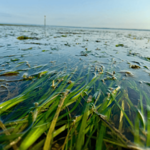
Scientists have warned efforts to protect and restore marine habitats along the UK’s coastline could be hindered by a lack of public knowledge about these initiatives. In the face of climate change and rising sea levels, nature-based coastal solutions (NBCS) are emerging as a sustainable and environmentally friendly way to protect our shores. These innovative solutions—which include living shorelines, engineered reefs, and restoration of saltmarshes and dunes—offer a greener alternative to traditional hard defenses like seawalls and barriers. However, new research reveals that while NBCS are preferred by many for their environmental benefits, public understanding of their effectiveness lags behind. In a study published in the Journal of Environmental Management, researchers surveyed over 500 UK residents and found a striking divide between public preference and their perception of effectiveness. Most respondents expressed a preference for nature-based coastal solutions due to their sustainability and aesthetic appeal. Yet hard defenses, which were long-established and visibly effective, remained widely thought-of as the most reliable way to mitigate coastal risks like flooding and erosion. Spatial distribution in preferences and perceived effectives for the two active coastal management strategies considered: hard defenses and nature-based coastal solutions. Credit: Journal of Environmental Management (2024). DOI: 10.1016/j.jenvman.2024.123413 The study highlights a critical knowledge gap. Although NBCS offer significant environmental advantages- including carbon sequestration, enhanced biodiversity, and community resilience—their long-term effectiveness is not well understood by the public. This disconnect could hinder efforts to implement NBCS at scale, despite growing calls from the coastal science community to adopt these solutions as a cornerstone of sustainable coastal management. To bridge this gap, researchers emphasize the need for greater public engagement and education about nature-based initiatives. Collaborative approaches, such as systems mapping, could play an important role in involving local communities in the decision-making process. By fostering dialogue among residents, scientists, and policymakers, systems mapping can help ensure that coastal management strategies are both inclusive and effective. Dr. Scott Mahadeo, from the School of Accounting, Economics and Finance at the University of Portsmouth, explains, “Nature based coastal solutions offer a promising path toward sustainable coastal management, combining environmental benefits with resilience against climate challenges. However, our findings highlight a clear knowledge gap between the scientific community’s advocacy for these solutions and the public’s understanding of their effectiveness. Bridging this gap through meaningful dialogue and inclusive decision-making will be key to fostering widespread support and ensuring robust, long-term coastal policies.” The study highlights that coastal zones hold deep socio-cultural significance, from family heritage and community cohesion to recreation and environmental stewardship. Researchers say that any changes to these landscapes can profoundly impact the lives and identities of coastal residents and users. This is why public support and understanding are crucial for the successful adoption of NBCS and other coastal management strategies. Dr. Mahadeo adds, “As the UK and the world grapple with the challenges of climate change, balancing innovative solutions with community needs is essential. The path forward lies in building trust, sharing knowledge, and working together to safeguard our coasts for generations to come.” The University of Portsmouth is involved in several projects that use nature as a potential solution to climate-related or pollution-related issues. These include the Rapid Reduction of Nutrients in Transitional Waters (RaNTrans) project, which is exploring how nature-based approaches can improve and protect marine ecosystems. Restoration projects are also underway across the south coast of England, including the pioneering Blue Marine Foundation’s Solent Oyster Restoration Project, and the UK’s first seascape restoration project the Solent Seascape Project. Both projects are based at the University of Portsmouth’s Institute of Marine Sciences in Langstone Harbour, and aim to restore multiple habitats such as oyster reefs, seagrass meadows, saltmarsh and birds, to reconnect and revive our ailing coastal waters. This latest study was conducted by a team of interdisciplinary scientists—in coastal geomorphology, environmental economics, and human geography—and focused on public perceptions of coastal management in the UK. Using innovative survey and analysis techniques, the authors hope the research will help develop more sustainable and inclusive coastal policies. More information: This article is republished from PHYS.ORG and provided by the University of Portsmouth.

Read More »