Tag: Citizen science

Seagrass app inspires a rise in citizen science across the globe

Internationally renowned charity Project Seagrass is marking it’s tenth anniversary by re-launching its citizen science website and mobile app SeagrassSpotter which enables anyone and everyone to engage with the seagrass meadows on their doorstep or anywhere else in the world, whether it’s there now or it once was. SeagrassSpotter was

Read More »

Where is all the seagrass? Project Seagrass wants you to help!

Help us record the seagrass near you At Project Seagrass we created a conservation tool that could lead to new discoveries about one of the ocean’s most underappreciated habitats — seagrass. With our new phone app and website, Seagrass Spotter, ocean enthusiasts around the British Isles can become citizen scientists who

Read More »

New Global map reveals seagrass meadows under threat — even inside protected areas

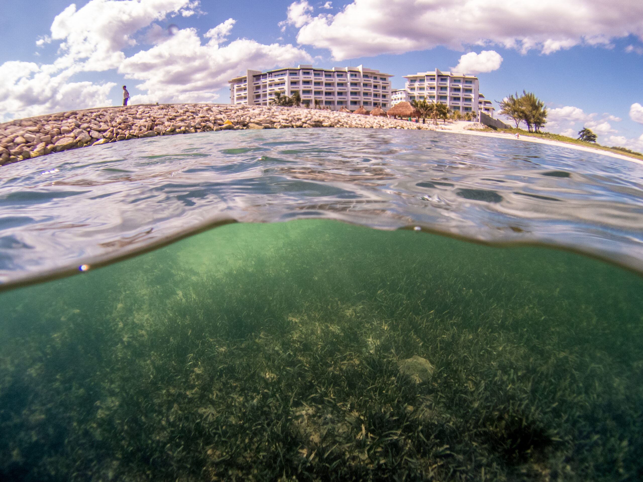
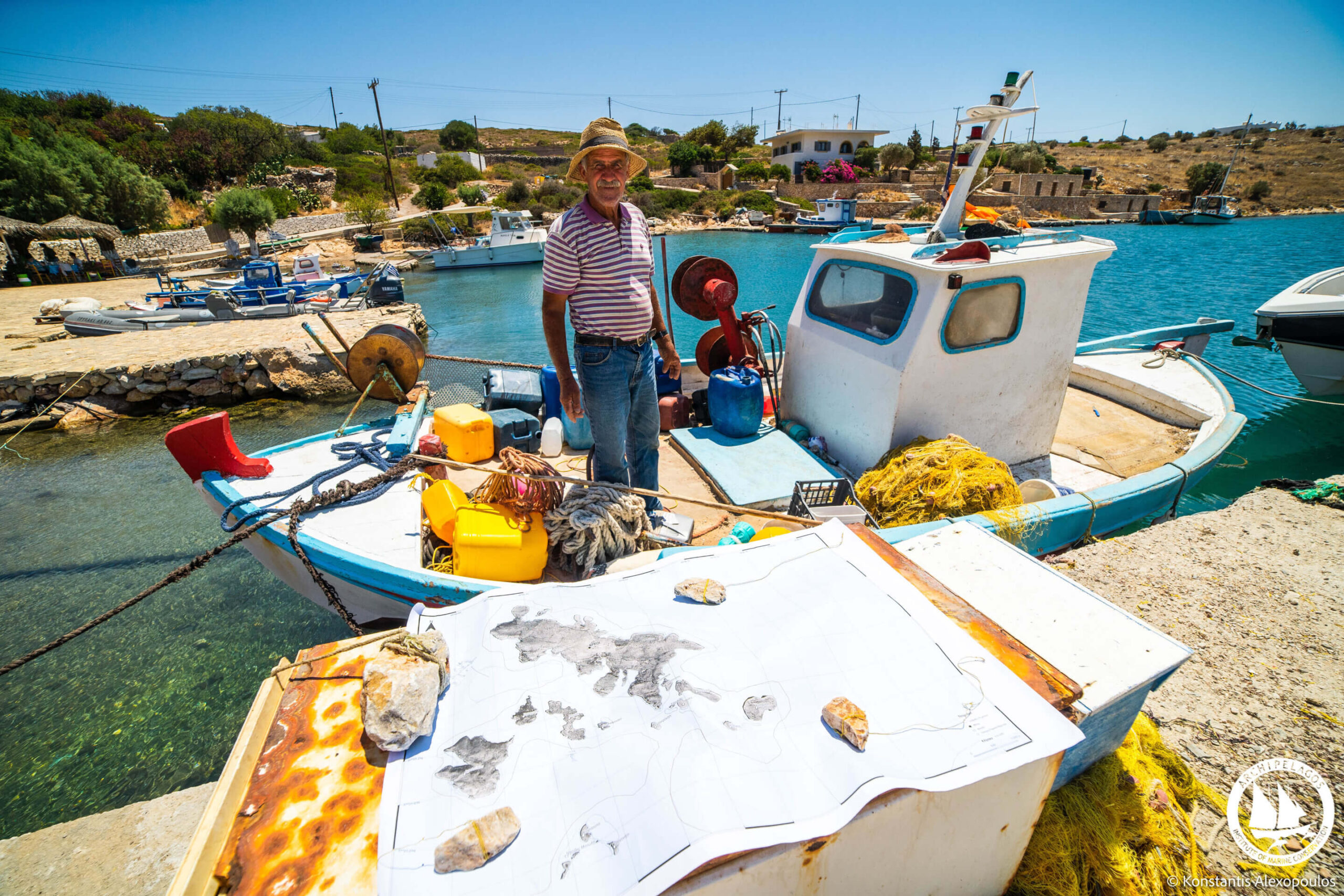
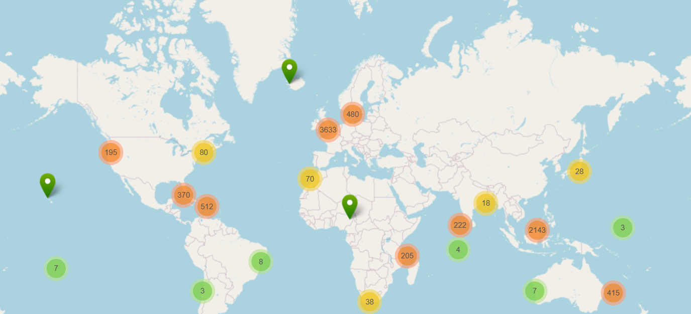
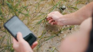
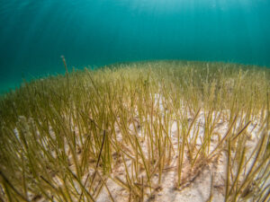
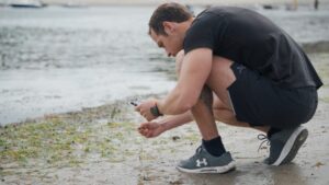
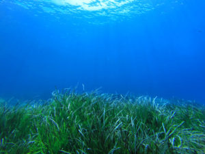
A new global analysis finds that many of the world’s most threatened seagrass meadows lie within designated Marine Protected Areas (MPAs), raising urgent questions about the effectiveness of current protections for coastal habitats and offering a chance opportunity to rethink global ocean conservation. The study, led by a team of scientists from the international NGO Project Seagrass, presents one of the most comprehensive global maps ever produced of the human pressures threatening seagrass meadows—vital coastal ecosystems supporting fisheries, and sustaining marine biodiversity in over 150 countries. With help from over 1000 citizen scientists, the team mapped human pressures to seagrass at over 1200 sites across 86 countries, finding that most seagrass meadows face multiple combined threats, including coastal development and pollution to impacts from things like boating, destructive fishing and aquaculture. Strikingly, half of the seagrass sites exposed to human impacts were located within MPAs—areas that are meant to provide refuge from such threats. “These are supposed to be safe havens for biodiversity,” said lead author Dr. Benjamin Jones. “Instead, we’re finding that many seagrass meadows inside MPAs are under intense and overlapping pressures from human activities on land. That’s a red flag—but also a huge opportunity to rethink how we protect seagrass meadows.” A wake-up call By analysing the data submitted by citizen scientists to SeagrassSpotter.org, the researchers created a high-resolution map of global seagrass vulnerability. The results reveal hotspots of concern in regions like Southeast Asia, the Mediterranean, and parts of the Caribbean—but also bright spots of lower pressure, where conservation action could be both timely and transformative. Critically, the study exposes a major gap between designation and implementation in the world’s MPA networks—finding that seagrass in 4.4% of the world’s MPA’s is under threat. “Putting a boundary on a map isn’t enough,” said Dr. Jones. “If we’re serious about protecting seagrass meadows—and all the benefits they offer—we need to start managing impacts from land.” The study calls for immediate action to strengthen protections within existing MPAs, prioritize high-threat zones for urgent intervention, and expand conservation to underrepresented but ecologically rich areas. “With just a small fraction of seagrass currently protected, the study makes a clear case for smarter marine spatial planning, localised threat reduction, and global cooperation,” said study co-author Dr. Richard Unsworth (also of Swansea University). The findings support the United Nations’ “30×30” goal to protect 30% of Earth’s land and ocean by 2030—but emphasise that quality of protection is just as critical as quantity. To achieve the Kunming–Montreal Global Biodiversity Framework targets, net seagrass losses of roughly 3,000 km2 must be avoided annually from 2030 onwards and ~95,000 km2 of these ecosystems must be restored. Meeting these targets requires solving the complex threats that most seagrasses around the world face. From threats to solutions By publishing the data from this study in an interactive map, the scientists hope this becomes a critical tool for policymakers, conservationists, and local communities who can now pinpoint some of the most at-risk areas and focus efforts accordingly. “Seagrass meadows are quiet powerhouses of the ocean,” said Dr. Jones, “[and] this new map shows us exactly where we need to act – not just to stop loss, but to invest in protection and conservation where it matters most.” Such conservation solutions, the authors argue, need not always be ocean based—land-based restoration and watershed management will be critical to combat nutrient pollution. “These threats are real and widespread. But the solutions are just as real and within reach,” said the team. “By mapping the threats, we’re also mapping the solutions. We know where to act. Now the world needs to do it.” Citizen science This global analysis represents the first research study using data from SeagrassSpotter.org, a citizen science platform launched a decade ago to engage the public in seagrass conservation. This milestone marks a significant achievement in seagrass science, showcasing the power of community-driven data collection. Over the past 10 years, volunteers from around the world have contributed thousands of observations, and Project Seagrass hopes this new research will inspire others to participate, and for fellow scientists to also harness the global dataset. The full article is available here. Jones, B. et al. (2025). Mapping global threats to seagrass meadows reveals opportunities for conservation. Environmental Research Ecology. https://doi.org/10.1088/2752-664X/adcacb

Read More »
A fisher stands aboard a boar. He is wearing a sunhat.

Artisanal fishers are almost as accurate as satellites in producing environmental data, study shows

Published in the journal Ocean and Coastal Management, the research set out to establish the value of local ecological knowledge (LEK) and its ability to generate high-quality habitat maps around five Greek islands in the eastern Aegean Sea. Ten fishermen, based on their individual experience and knowledge, were asked to pinpoint areas where they believed seagrass beds could be found along the coastlines of their respective islands. The maps they produced were then compared with satellite data of the same regions, with analysis showing an average accuracy of 78% – and a high of 92%. The fishermen’s maps were also 11% more accurate than those used by the Greek government in the development of environmental policies, with more than half of the government maps underestimating the scale of seagrass beds found across the region. The researchers say their findings are a clear demonstration of the value of tapping into local knowledge, and how doing so can be a low-cost means of generating environmental data without compromising the high accuracy needed for the data to still be valuable for policy use. Ten fishermen, based on their individual experience and knowledge, were asked to pinpoint areas where they believed seagrass beds could be found along the coastlines of their respective islands. Credit Konstantis AlexopoulosUniversity of Plymouth The study was carried out by researchers from the University of Plymouth and the Archipelagos Institute of Marine Conservation. They worked closely with fishermen on the islands of Fourni, Arki, Patmos, Lipsi and Leros, each of which are home to communities made up largely of small artisanal fishing vessels. Konstantis Alexopoulos, a BSc (Hons) Ocean Science and Marine Conservation graduate from the University of Plymouth, now pursuing a Ph.D. with the Scott Polar Research Institute at the University of Cambridge, is its lead author. He said, “Some of the fishermen we spoke to had been sailing the same waters every day for more than 60 years. That experience has given them a huge amount of knowledge, but we wanted to test precisely how accurate their empirical data were in comparison to more traditional sources of information. “For some personal recollections to be 90% as accurate as the data provided from satellites is really impressive, and something we should be taking into greater account. It also highlights the importance of gathering such information, as there is a huge wealth of data within local fishing communities that is otherwise at risk of being lost as fewer younger people enter the profession in the future.” Those involved in the research say it is another example of how communities, scientists and decision-makers could work in collaboration to meet ambitions set out within the United Nations Sustainable Development Goals. And despite it being centered around the eastern Aegean Sea, they believe their findings – and the methods used to reach them – will be relevant in other parts of the ocean. In particular, they say LEK could play a pivotal role in generating a greater understanding of deeper marine ecosystems which satellites can’t see and for which there are currently little or no maps available to guide management decisions. Dr. Abigail McQuatters-Gollop, Associate Professor of Marine Conservation at the University and the current study’s senior author, added, “There is a huge global drive to get more people involved in projects that incorporate elements of citizen science. “Despite that, expert local ecological knowledge is still being dismissed or discredited by those making decisions about the environment. But just because information hasn’t been generated by expensive technology, it doesn’t make it any less valuable. “Using people’s life experiences, gathered from fishing and living in an area over many years, alongside other scientific data can help us develop and implement actions that maintain a healthy global ocean.” More information: Konstantis Alexopoulos et al, Is sparse local ecological knowledge accurate enough for policy? A seagrass mapping case study from five Greek islands in the Eastern Aegean Sea, Ocean & Coastal Management (2025). DOI: 10.1016/j.ocecoaman.2025.107627

Read More »
A map of the world showing where seagrass has been spotted using SeagrassSpotter

SeagrassSpotter data validates model for mapping seagrass in shallow coastal environments

To protect and restore seagrass, we need reliable maps showing where seagrass is growing and how this is changing over time.  Global seagrass distribution and status is difficult to map and monitor, largely due to its widespread distribution and the relatively limited scientific resources focused on seagrass. Mapping work to date has been a slow and expensive process with the status of many seagrass meadows remaining unknown. However, by combining emerging technology with community-powered science we can speed up this process. A recent study has developed a novel deep learning model ( SGDenseNet) that uses satellite imagery to map seagrass meadows more efficiently. To test the accuracy of the model, the researchers used SeagrassSpotter data to help validate the study. Classification results on 1,067 locations from Seagrass Spotter project. Green points indicate locations where the SGDenseNet model correctly classified the presence of seagrass, while red points represent locations where the model misclassified the data. Source: Peng, et al 2025 How SeagrassSpotter Data Helped Researchers used 1,067 independent seagrass field data samples from SeagrassSpotter to test the accuracy of their deep learning model. The SGDenseNet model correctly identified seagrass  81% of the time when compared to real-world SeagrassSpotter data suggesting the model has significant potential for helping researchers track seagrass globally, making conservation efforts more targeted and effective.  One of the biggest challenges in mapping seagrass is telling seagrass apart from similar-looking underwater habitats such as algae, coral, and sand. These environments often have overlapping spectral signatures—essentially, the way different materials reflect light—which makes them hard to distinguish using traditional methods. By using deep learning, the SGDenseNet model was able to analyse subtle spatial differences and improve accuracy significantly. It’s for these reasons that we created a separate “absence” feature within SeagrassSpotter, to track places where seagrass isn’t growing, which can help researchers differentiate different habitats that may look like seagrass from space.   We often get asked, “Where does SeagrassSpotter data go?” This study is a perfect example of how your contributions help to drive real scientific progress. By sharing your sightings, you’re not just taking a photo—you’re helping scientists build better tools to protect seagrass around the world. SeagrassSpotter data has also been utilised as part of other research including a study assessing how genetic variation and genetic differentiation vary among Zostera marina meadows in Northern Europe and as part of a study assessing the effect of wave exposure on sedimentary carbon and nitrogen accumulation in Zostera marina meadows at the Swedish west coast. Want to be part of this effort? Download the SeagrassSpotter app, log your sightings, and make a difference for the future of our oceans!  

Read More »
Someone crouched on the beach is taking a photo of seagrass to upload to SeagrassSpotter

Community, Connection, Conservation: latest SeagrassSpotter Updates

The Project Seagrass team have been busy working on a range of new features within SeagrassSpotter. Since our last major update in 2023, we have been working to further enhance your experience when participating in the programme and are super excited to share the latest developments. In response to your feedback, the new functionality focuses on introducing ways for you to interact with each other, as well as introducing an element of healthy competition as we seek to widen our reach, grow the community mapping the world’s seagrass, and contribute to solving global challenges for seagrass! One of the six global challenges facing seagrass conservation is obtaining and maintaining information on the status and condition of seagrass meadows around the world. SeagrassSpotter makes a vital contribution to this, providing open access seagrass data that has been used in various scientific publications, from deep learning algorithms, to accessing genetic connectivity of seagrass populations. Explore some of the new functionality below: Leaderboards Think Duolingo, but for seagrass! The new Leaderboards within SeagrassSpotter showcase users with the Most Sightings, Most Countries Visited, and highest number of Species Found. With Yearly and All Time views available, users have a range of options to explore the sightings of their fellow SeagrassSpotters. And if your competitive spirit inspires you to head out to your local beach in search of seagrass, we’d love to see your sightings! Achievements Following the latest update, you might have noticed some new badges on your profile. This forms part of a host of new Achievements that SeagrassSpotter users can work towards. Ranging from the number of sightings uploaded to more specific achievements such as taking a photo with seeds or flowers or, there are a range of different achievements to unlock. Interactivity Users now have the opportunity to interact with each other’s seagrass sightings. Alongside new Like and Comment functions, users can now Favourite a seagrass sighting, making it easily accessible to find again via the My Favourites section in My Profile.  Users can also make use of a new ‘I’ve spotted this too’ function, helping the community to confirm data points for sightings. We love to hear your feedback! SeagrassSpotter is constantly developing in response to its users. Please send any comments or feedback you have to seagrassspotter@projectseagrass.org .

Read More »

You asked, we listened. Our latest updates to SeagrassSpotter

Things have been busy at Project Seagrass with lots of development on SeagrassSpotter. Since our last major update, we have been working to enhance the ways that SeagrassSpotter works for its users. We’re excited to share that our latest update includes many of the features you have been asking for, and a few more. One of the six main global challenges to seagrass conservation is that the status of many seagrass meadows is unknown, and up-to-date information on status and condition is essential for conservation. While we’re making great strides in using drone technology and satellite imaging for seagrass mapping, new technologies still depend on “ground-truth” data, which is where SeagrassSpotter comes in. This is how individuals can make lasting contributions to seagrass conservation. With this in mind and coupled with the requests you’ve made, we’ve released a new version of SeagrassSpotter. We’ve developed a completely new exploration and filter function, allowing you to select data from certain species, countries, and more. We’ve also made it easier for you to download SeagrassSpotter data and generate reports on the things that matter most. Finally, we’ve added a completely new upload function for absence data; places where seagrass isn’t found or used to be found but now isn’t – data that will help us and other transform habitat suitability modelling. Take a look at our feature recaps below to learn about each one in depth.   Data exploration We understand the importance of being able to view the data you collect – you can see in real time how you’re contributing to the bigger picture. Data exploration is the first step of data analysis and is used to explore and visualize data to uncover insights from the start or identify areas or patterns to dig into more. Using interactive filtering, users can better understand the bigger picture and get to insights faster. You can filter data by any of the parameters that SeagrassSpotter collects (e.g., algae, fishing activity, flowering) and display this either in grid format or map format. Report generation In addition to our new explore tab, we’ve added new report generation features that allow you to download data that is filtered by any of the parameters that you select. Only want seagrass data from the Philippines? No problem! We understand the importance of being able to easily download data and have worked to remove barriers to this. All SeagrassSpotter data is free to access, and you don’t even need to sign up for an account. Open Access data will make conserving seagrass easier for everyone. Absence data It’s imperative that we know where seagrass is growing, but to advance seagrass restoration, it’s also important that we know where seagrass isn’t growing, and why. Whether it’s been lost, or simply was never found there in the past, our new absence data function allows you to add data on other habitats and substrates such as mangroves, coral, seaweeds, rocks, sand and mud. This will make habitat suitability modelling easier and more efficient, while also adding greater ground truthing needs for remote sensing. New languages We understand that for SeagrassSpotter to be a global tool, it needs to be accessible to all, no matter what language you speak. Over the past few years, we’ve slowly been adding additional languages to increase usability in many of the countries we work. Alongside this, we’re developing an app within SeagrassSpotter called SpotLang that provides a means for anybody to help curate new languages with us. As it currently stands, SeagrassSpotter is available in nine languages; English, Welsh, French, Portuguese, Swahili, Thai, Bahasa Indonesia, Bahasa Malay and Tetun. If you are interested in contributing to new languages, please get in touch.

Read More »

Seagrass app inspires a rise in citizen science across the globe

Internationally renowned charity Project Seagrass is marking it’s tenth anniversary by re-launching its citizen science website and mobile app SeagrassSpotter which enables anyone and everyone to engage with the seagrass meadows on their doorstep or anywhere else in the world, whether it’s there now or it once was. SeagrassSpotter was established in 2016 and allows people to upload point data showing the presence of seagrass with photo evidence. Since its initial launch, it has gathered over 7,000 sightings of seagrass from over 3,500 users across 105 countries and has recorded 45 species of seagrass. It’s relaunch will include new features, such as being able to record absence data to track where seagrass may have once existed but is now lost. Dr Leanne Cullen-Unsworth, CEO at Project Seagrass, said: “Over the last ten years, we have successfully raised awareness of the importance of seagrass and the role it plays in tackling the biodiversity and climate crises. Now we must accelerate efforts to protect and restore this vital habitat. Everyone can have a part to play in securing a future for seagrass and SeagrassSpotter is a great tool to engage and connect people in seagrass science and mapping all over the world.” The UK alone has lost up to 92% of its seagrass meadows, an essential ecosystem that protects our coasts, supports the fishing industry, and puts food on our tables. To monitor, identify and stop the loss of seagrass all over the world, Project Seagrass is calling for more people to engage in citizen science and not only record where seagrass meadows can be seen, but where they once were and now no longer are. Saving the world’s seagrass meadows is an essential task if we are to address both the climate and biodiversity crises, but making waves to do this requires the many, rather than the few. Seagrass has long been the unknown and forgotten oceanic plant, a plant that was once terrestrial, and is now becoming a household name as we learn more about its significance to both people and planet. For instance, seagrass supports 20% of the world’s largest commercial fisheries, therefore without it, our fish stocks will continue to drastically reduce. There are also communities all over the world who are dependent on seagrass, as their main food source, fish, derives from their local seagrass meadows. When considering nature-based solutions, seagrass meadows are high on the agenda and a hot topic for carbon sequestration and biodiversity support, however, the science required to evidence the quantities is not yet complete. We therefore have much to do in the next decade to ensure we protect the seagrass we have and put back what we have lost. To achieve this, we must all play our part, which is why citizen science is on the rise. With more people actively engaging in local projects, now is the perfect opportunity for Project Seagrass to re-launch their citizen science web platform and phone app, SeagrassSpotter. To explore the SeagrassSpotter tool visit https://seagrassspotter.org/

Read More »

Seagrass citizen science: investigations into a potential seagrass saviour

A guest blogger? But why should I bother reading what he has to say? Well here’s a bit about me…. Originally hailing from Melton Mowbray, a small town in the middle of England known solely for producing pork pies and stilton cheese, my initial foray into marine science began with any other child’s obsession with the beach. My parents often remind me that after hours of poking around in rockpools and catching crabs I would throw tantrums when it was time to leave the coast and return to my landlocked home. As I became older and words like career and jobs became ever more prevalent in my life, I began searching for the holy grail of adult life, a job which I genuinely enjoyed. This search led me to undertake a Bachelor’s degree in Coastal Marine Biology in the now non-existent Scarborough Campus of the University of Hull; I should clarify that my class was the last year to graduate from that tiny seaside town before the satellite campus shut down. It was during my time as an undergraduate researching in the Aegean Sea that I first encountered seagrass ecosystems and immediately fell in love. Seagrasses are the only true marine angiosperm (flowing plants) and have been described by Professor Carlos Duarte (a famous seagrass scientist) as ugly duckling ecosystems. After returning from that career changing trip all my subsequent assessments were targeted towards seagrasses as I endeavoured to learn all I could about their function, ecology and reproduction. A room with a view… daily scenery when completing Aegean seagrass surveys. This obsession permeated through to my Master’s degree at the University of York in Marine Environmental Management where my supervisor shared a passion for these underappreciated ecosystems; it seemed fate had brought two seagrass nerds together at last. As I continued through the MSc with a specific focus on seagrasses when possible there came a time where I had to find an external placement partner to complete my second thesis with. Being still constrained firmly to the student financial situation I did not have the prospect of travelling to far flung places as some of my peers. However, this hardly mattered as my first choice was to work with the only active group of seagrass researchers in the UK, Project Seagrass! After finalising the logistics of the project and “upping sticks” to Cardiff in mid-July I now right this blog post sat at a desk in Project Seagrass HQ nestled in a surprisingly sunny Cardiff. But that’s enough about me, let’s talk seagrass citizen science! The project I am completing investigates the motivations, benefits, barriers and changes in knowledge associated with taking part in seagrass citizen science projects, specifically SeagrassSpotter and Seagrass-Watch (follow the links if you want to learn more about these projects). More broadly the project sets out to discover who is taking part, why they take part and when they take part. The project itself is being co-managed by myself and Isadora Sinha of Cardiff University who is heading up the demographics (the who) associated with the project. Throughout the project we utilised an online questionnaire which has been disseminated to current users of SeagrassSpotter, Seagrass Watch, and various seagrass-based email and social media groups (yes seagrass Facebook groups exist, if you’re interested you should join one). Given that citizen science, the participation of non-scientists in scientific research, has been labelled as a source of large data sets across varied space and time, seagrass citizen science has the potential to alleviate some of the primary threats these ecosystems face. Talking all things seagrass citizen science at a workshop organised by Cardiff University. Seagrasses are thought to be declining at around 7% a year, with declines primarily due to changes in water quality and increases in suspended sediments which reduce the ability of the plant to photosynthesise by blocking available sunlight. Additionally, researchers have little idea of local spatial coverages of seagrasses due in no short part to a chronic lack of public awareness of their existence; a concept which doesn’t apply to more charismatic ecosystems such as coral reefs. This decline represents not only the loss of a beautiful marine habitat (see the photo below if you don’t believe me) but also the services these ecosystems provide. Seagrasses are present on the coastal fringes of almost all continents worldwide where their presence promotes high primary and fisheries productivity, in turn supporting food security worldwide. You know the cod that forms an integral part of your chippy tea? Well it probably spent a good part of its juvenile years living in and around seagrass meadows. Seagrasses also add 3D structure to muddy bottoms, enhancing sediment capture which stabilises coastlines against erosion and acts to trap carbon dioxide helping to combat climate change. It is therefore hoped that by better understanding why people take part in seagrass citizen science we can reduce barriers to participation and increase public awareness and conservation of these crucial ecosystems. The project also represents the first time these topics have been studied in a seagrass specific context so will provide much needed insight into the finer state of seagrass citizen science. For a global review of seagrass citizen science see this article led by Project Seagrass Director Benjamin Jones (sorry, it’s not open access). At the time of writing the survey has been sent to over 1000 people and has been completed around 60 times. This may not seem like a worthwhile return, but such a small number of responses is common among online surveys. Results from the survey are being collated currently and will be prepared ready for my MSc thesis submission in early September. So, watch this space for seagrass updates! Together we can promote conservation and raise awareness of seagrasses to help this ugly duckling become beautiful swan.

Read More »

Where is all the seagrass? Project Seagrass wants you to help!

Help us record the seagrass near you At Project Seagrass we created a conservation tool that could lead to new discoveries about one of the ocean’s most underappreciated habitats — seagrass. With our new phone app and website, Seagrass Spotter, ocean enthusiasts around the British Isles can become citizen scientists who contribute to marine conservation, with just a few taps of their phone. We’ve made important scientific breakthroughs with seagrass in recent years, but they remain incredibly threatened and are still underappreciated in our British Isles. Seagrass remains threatened and under appreaciated in our British Isles The Problem Seagrass meadows in the British Isles have recently been highlighted for their value as fish nurseries for commercially important species (e.g. Pollack, Herring Atlantic Cod, Plaice), this adds to our existing knowledge of their high ecosystem service value throughout Europe. Despite their importance seagrass meadows are in a degraded and perilous state in the British Isles having experienced significant losses over time. Estimates suggest that between 25% and 80% of UK seagrass has been lost since the 1930s with minimal signs of recovery. Significant threats in the British Isles include direct physical damage (e.g. from boating or trampling), increased sedimentation and poor water quality. Confounding the problem is a lack of public awareness of the existence and value of seagrass meadows. Seagrass Spotter With Seagrass Spotter, we want to map and record more of the seagrass here in the British Isles to be able to help protect it for future generations. Seagrass Spotter seeks to expand the number of people studying seagrass from a handful of scientists to hundreds and potentially thousands of ‘citizen scientists.’ As part of efforts to build a sustainable monitoring network, and by leveraging the enthusiasm of everyone from fishers to SCUBA divers and from wildlife enthusiasts to tourists, we’ll create a more comprehensive picture of seagrass meadows around our British Isles. To protect our critically important seagrass meadows we need to first know where they are, understand their importance, and know the things that might damage them. Whilst the British Isles has a proud history of biological recording, seagrasses have rarely figured in that data collection. We want to change that. When we don’t know where seagrasses are, then these habitats that provide so many important functions to our coastal seas can disappear without anyone even noticing. Studying seagrass is challenging. It requires time, energy, funding and experts willing to conduct research. Governments, Universities, NGO’s all try and do this vital mapping work but it’s too expensive and time consuming, especially in an era of austerity. Relying on data only gathered by experts leaves a huge deficit in our information and this is where citizen scientists come in; observations made by members of the public can help bridge the gap in our knowledge, as in many areas of the British Isles basic distribution information is still badly needed. The idea is simple and we’re inviting the public to upload photos of seagrass from known locations around the British Isles using either the phone app or directly on the website. Together with submitting photos we’re also asking contributors to answer some simple questions about the seagrass at the site. However, we don’t expect contributors to have prior knowledge of marine biology and the website and app will provide all the information you may need. The phone app is available from Google Play (iPhone version to be released early May) and the website is accessible through any format. Please take a look at www.seagrassspotter.org for more details or to download the app search ‘Seagrass Spotter’ in Google Play or follow this link here. This application is currently only applicable for use in the geographic area of the British Isles but we’re currently looking to find sponsorship to turn this tool into a global resource.

Read More »